
 Ginger R. Tolbert, P.E. attended software training on Haestad Method’s SewerCAD and an advanced training sessions on WaterCAD September 11-15, 2006 in Watertown, Connecticut. These advanced training courses provided discussions and hands-on workshops on capacity analysis, rehabilitation, new system design, model calibration, pump selection and master planning for water and wastewater collection systems. Both steady-state and extended-period simulations were presented. Mrs. Tolbert has been using WaterCAD (previously known as Cybernet) for more than ten years as a tool in analyzing municipal water systems.
R. David Patrick, P.E. and John A. Simcik, P.E. attended the Federal Emergency Management Agency (FEMA) 4-Day National Flood Insurance Program (NFIP) Course held in College Station, Texas from September 11-15. The course was presented by FEMA Region VI staff in partnership with the Texas Floodplain Managers Association (TFMA) and the Texas Department of Transportation (TxDOT). The course, titled “Managing Floodplain Development through the National Flood Insurance Program” provided intensive training for managing new and existing development within floodplains. After the conclusion of the course, both Mr. Patrick and Mr. Simcik completed and passed the exam to become Certified Floodplain Managers (CFM).
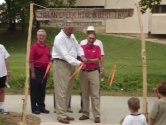 On June 30, 2006 Belton Mayor Jim Covington and City Manager Sam Listi ‘snipped’ the ceremonial barbed wire to officially open the Nolan Creek Hike & Bike Trail. Barbed wire was used in place of the traditional red ribbon to keep with the Chisholm Trail theme that can be seen throughout the project. Also in attendance were current and past City Council Members and Mayors, a former City Manager, representatives of the Texas Department of Transportation, representatives of Barsh Company, representatives from Kasberg, Patrick & Associates, LP and a hundred or so citizens of Belton.
Construction on the $1.78 million, 1.5 mile trail began in early September of 2005. The project consisted of 1.5 miles of a 10’ concrete trail, 500’ of retaining walls, six pocket parks, two parking lots, seven box culvert crossings, a pedestrian bridge and a low water crossing of Nolan Creek.